
UPI.com By Jean Lotus February 6, 2020
DENVER, Feb. 6 (UPI) — More wildlife overpasses and underpasses are coming to highways in the western United States, thanks to a better understanding of migration corridors boosted by GPS collar technology.
Utilizing now-affordable tracking collars, wildlife researchers have learned that deer and other animals that dart into the road are driven by an ancient instinct to follow migratory paths in existence long before automobiles were introduced.
A meeting last summer of the Western Governors Association brought new focus on migratory corridors and how to create more wildlife crossings. Additional crossings to help protect animals are planned in Montana, Wyoming, Colorado, Oregon and California.
States are seeking more money for wildlife crossings from highway funds via the federal Fixing America’s Surface Transportation Act, which expires this year. They say the need is great, and they cite the danger to both motorists and animals from sudden, unexpected collisions.
Between 1 million and 2 million vehicle collisions with large animals occur every year in the United States, according to the U.S. Federal Highway Administration. Those collisions cause almost 30,000 injuries and about 200 deaths a year — and billions of dollars in auto repair costs.
Hitting a moose
“Really traumatizing” was how Jill Randall described hitting a migrating moose on Wyoming’s U.S. 191, locally nicknamed “the gauntlet” near Trapper’s Point.
Randall, based in Pinedale, Wyo., is big-game migration coordinator for Wyoming’s Department of Game and Fish. “If you drive enough of those roads, [animal collisions] just happen,” she said.
Multiple wildlife crossings, costing $9.4 million, and about 12 miles of fencing in her state have caused collisions to drop by more than 80 percent, she said.
Pinedale is a crucial spot on the migration paths of moose, as well as North America’s longest migration paths of mule deer and pronghorn antelope, as mapped out by biologists using radio collars.
“I love waking up in the morning and seeing moose in my backyard,” Pinedale Mayor Matt Murdock said. But no one wants to encounter one on the road.
Keeping wildlife corridors connected gives animals a better chance of species survival, said Matt Skroch, a Portland, Ore.-based manager for the Pew Charitable Trusts. He focuses on these corridors.
“We have known large herds of animals were migrating across the west since European settlement, but we didn’t have a good sense of where they went,” Skroch said. “These GPS collars represent an age of discovery that gives us new information that will allow us to make better policy decisions to conserve this migratory habitat.”
Populations of mule deer are dropping across the country, Skroch said, due in part to fragmented habitats broken up by roads and human encroachment, including mining and gas extraction, housing developments and agriculture.
Nevada roadkill
Nevada was among the first states to create wildlife overpasses in 2010. Thousands of migrating mule deer in rural Elko County caused havoc every year as they darted across Highway 93, leaving destroyed vehicles and hundreds of roadkill carcasses every spring.
Wildlife migration routes were mapped onto carcass records and crash data to construct the bridge.
“It becomes really obvious where the deer want to cross when you look at the carcass retrieval records,” said Kari Huebner, game biologist for the Nevada Department of Wildlife. “Then the engineers decide where to put the crossing.” Eight-foot fencing funnels the animals to the wildlife bridge.
In the past decade, Nevada’s highway department built six other animal crossings, including one across Interstate 90. Collisions have dropped by 90 percent and at least 37,000 mule deer have used the crossings in the past 10 years, officials said.
Netting from helicopters
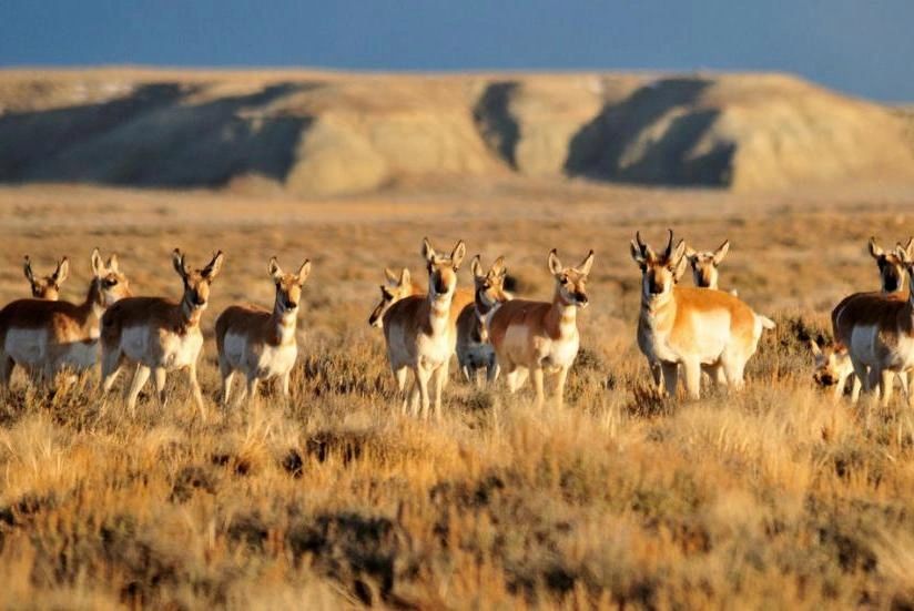
In Wyoming, wildlife scientists using radio collars have mapped out the longest mule deer migration in the world — 150-mile trek from southwest Wyoming’s Red Desert to an area called the Hoback. They’ve also mapped the 100-mile Path of the Pronghorn between Pinedale and Grand Teton National Park.
Deer and antelope are netted from helicopters, and then rangers transport them, blindfolded and hobbled, to health-checking stations where they snap on the collars.
Radio collars can transmit for several years, and will detach and fall off when batteries die, migratory biologist Jill Randall said. Collars cost about $500 each, plus data fees. Some grant money for migration projects have been available from the U.S. Department of Interior, Randall said.
Collar data has tracked the fidelity of mule deer fawns who return to “within 200 yards” of the same spot they were born, Randall said. “It’s learned behavior from mom.”
Animals migrate from high-altitude summer feeding and fawning grounds to forage areas where snow is not as deep. Then, in the spring, they “surf the green wave,” following sprouting new grass back up the mountains, wildlife scientists said.
Pronghorn antelope make an unlikely sojourn through natural bottlenecks over cliffs and snow-filled passes, GPS data shows. They dart through timbered forests and swim rivers, said Jackson Hole-based Mark Gocke of Wyoming Game and Fish.
“These are all habitats where pronghorn feel vulnerable. We didn’t expect to find them in the same [cliff] habitat with bighorn sheep, but that’s where they go,” Gocke said.
Animals pay no mind to human boundaries or whether land is owned by federal, state or private parties, and that can conflict with human uses of the land, Randall said.
About 5,000 mule deer migrate across private property at a pinch point near Fremont Lake, near Pinedale.
“It was undeveloped sagebrush habitat, land with a great lake view, with a high potential for development,” Randall said. When identified by GPS data, a group of private entities led by the Conservation Fund bought the property from the landowner and donated it to the Wyoming Game and Fish Commission, she said.
Pinedale’s mayor Murdock said migration corridors need to be balanced with recreation use and land for oil and gas extraction, which employs many area residents.
“It’s an interesting seesaw to keep everybody balanced,” he said.
A 2018 wildlife corridor protection order from then-Secretary of the Interior Ryan Zinke directs state and federal agencies to prioritize habitats within migration corridors in the West.
“The science [from the GPS collars] is the building block of the momentum,” Pew’s Skroch said. “This is allowing the states and the federal agencies to make better policies to protect wildlife habitat and improve highway safety.”